<< altimetry | altitude | altitude chamber >>
Back to: "A"
altitude
- Definição1
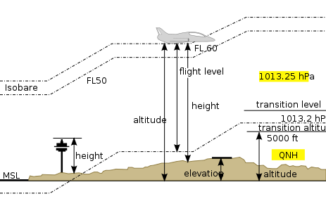
- The height of an object expressed in units of distance above a reference plane, usually above mean sea level (MSL) or above ground (AGL).
- Fonte1
- CRANE, Dale (ed.). Dictionary of aeronautical terms. 2nd ed. Renton: ASA, 1991.
- Definição2
- A measure (or condition) of height, especially of great height, as a mountain top or aircraft flight level.
- Fonte2
- AMERICAN METEOROLOGICAL SOCIETY. Glossary of meteorology. [S.l., última modificação 05 oct. 2015]. Disponível em: < http://glossary.ametsoc.org/wiki/Main_Page >. Acesso em: 11 dez. 2019.
- Definição3
- Vertical distance of a level, a point or an object considered as a point, measured from mean sea level
- Fonte3
- WORLD METEOROLOGICAL ORGANIZATION. International meteorological vocabulary. 2nd ed. Geneva, 1992. (WMO, n.182). Disponível em: < https://library.wmo.int/index.php?lvl=notice_display&id=220#.XeauGOhKiUk >. Acesso em: 18 fev. 2020.
- Fonte4
- WORLD METEOROLOGICAL ORGANIZATION. Manual on codes: international codes. Volume I.2: annex II to the WMO technical regulations. Parte B: binary codes. Parte C: common features to binary and alphanumeric codes. Geneva, 2015. (WMO, n.306).
- Nota adicional1
- In meteorology, altitude is used almost exclusively with respect to the height of an airborne object above the earth's surface, above a constant-pressure surface, or above mean sea level. The measurement of altitude is accomplished by altimeters in aeronautics, and the entire study is called altimetry.
- Contexto
- The average altitude of cloud bases and tops is reported for hshs and HtHt, respectively.
- Subárea1
- Aeronautical Meteorology
- Related Term
- elevation
- height
- true altitude
- Narrower Term
- minimum descent altitude
- Português
- altitude
- Imagem


