Inglês/Espanhol
<< eletric starter | elevation | elevator >>
Back to: "E"elevation
- Sinônimos
- gravity-related height
- Definição1
- The vertical distance of a point or a level, on or affixed to the surface of the earth, measured from mean sea level.
- Fonte1
- INTERNATIONAL CIVIL AVIATION ORGANIZATION. International civil aviation vocabulary. 3rd ed. Montreal, 2007. (Doc. 9713).
- Fonte2
- INTERNATIONAL CIVIL AVIATION ORGANIZATION. Aircraft Operations: Flight Procedures. Volume 1. 5th ed. Montreal, 2010 (Doc 8168).
- Nota adicional1
- Acronym in English: ELEV.
- Nota adicional2
- Information regarding this term is a result of researches developed by DECEA in cooperation with ANAC.
- Contexto
- The air traffic controller shall not issue the heading instruction to the aircraft below 120 m (400 ft) above the runway threshold elevation.
- Subárea
- Aeronautical Information
- Aeronautical Cartography
- Related Term
- aerodrome elevation
- hypsometric tints
- Spanish
- elevación
- Imagem
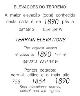
Image 42 Indication of the highest point.
Fonte: BRASIL. Comando da Aeronáutica. Departamento de Controle do Espaço Aéreo. MACAR: manual de confecção de cartas aeronáuticas. Cartas VFR. Rio de Janeiro, 2014. Disponível em: http://publicacoes.decea.gov.br/download.cfm?d=4015. Acesso em: 03 set. 2014.
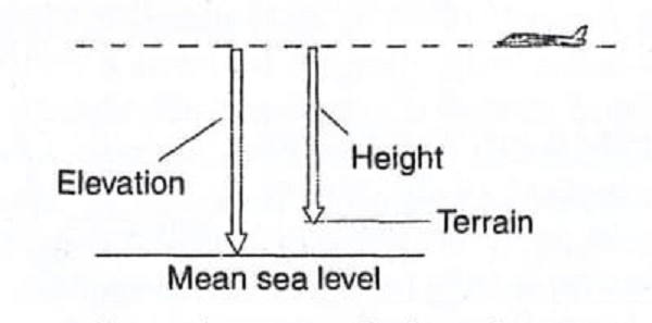
Elevation.
Fonte: KUMAR, Bharat (ed.). An illustrated dictionary of aviation. New York: McGraw-Hill, c2005. 752 p.