Inglês/Português
<< global aviation safety plan | global navigation satellite system | go-around >>
Back to: "G"global navigation satellite system
- Definição1
- Satellite navigation system that provides autonomous geospatial positioning with global coverage. It allows small electronic receivers to determine their location (longitude, latitude, and altitude) to within a few meters using time signals transmitted along a line of sight by radio from satellites.
- Fonte1
- FEDERAL AVIATION ADMINISTRATION. Pilot's handbook of aeronautical knowledge. [s.l.], 2008. Disponível em http:// www.faa.gov/regulations_policies/handbooks_manuals /aviation/pilot_handbook/media/PHAK %20-%20Cover-Preface.pdf. Acesso em: 26 jun 2014.
- Definição2
- An umbrella term adopted by the International Civil Aviation Organization (ICAO) to encompass any independent satellite navigation system used by a pilot to perform onboard position determinations form the satellite data. GNSS means any navigation system that satisfies stated international navigational requirements using satellite technology. A complete global navigation satellite system may include satellites provided by various states and commercial groups and be complemented by ground systems used to augment and monitor the satellites.
- Fonte2
- KUMAR, Bharat (ed.). An illustrated dictionary of aviation. New York: McGraw-Hill, c2005. 752 p.
- Fonte3
- AGÊNCIA NACIONAL DE AVIAÇÃO CIVIL. IS 21-013: instruções para obtenção de aprovação de instalação de equipamentos GNSS (Global Navigation Satellite Systems) stand alone para operações VFR e IFR PBN (Performance-Based Navigation). Instruções para obtenção de aprovação de instalação de equipamentos GN. Brasília, 2012. Disponível em: http://pergamum.anac.gov.br/arquivos/IS21-013A.PDF Acesso em: 11 out.2013.
- Nota adicional1
- Acronym in English: GNSS.
- Subárea1
- Air Navigation
- Português
- sistema global de navegação por satélite
- Imagem
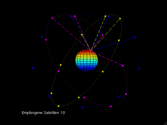
The Animated gif shows the constallation of the Galileo Satellites, how they are moving around the earth, and how many satellites are seen from a point of the Earth.
Fonte: http://commons.wikimedia.org/wiki/File:Galileo_sat_constallation.gif?uselang=es

Navigation Satellite System used in an oil tanker: electronic nautical charts.
Fonte: http://commons.wikimedia.org/wiki/File:Navigation_system_on_a_merchant_ship.jpg?uselang=es